

Kopili Fault Zone: A Silent Threat Beneath Assam
The
Northeast region of India, especially Assam, sits precariously on one of the
most seismically active belts of the world. Among its most significant tectonic
structures lies the Kopili Fault Zone (KFZ) - a deeply seated fracture system
stretching across Assam, Manipur, Bhutan, and Arunachal Pradesh. With a long
history of destructive earthquakes and continued tectonic stress, this fault
line represents one of the gravest natural threats to the region’s stability
and safety.
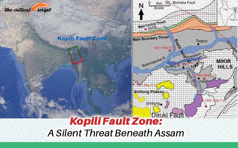
What is the Kopili Fault Zone?
The Kopili
Fault Zone is a northeast-trending fault system approximately 300 km long and
50 km wide. It originates in western Manipur, traverses through Assam, and
extends up to the Bhutan–Arunachal–Assam tri-junction. Classified geologically
as a transpressional fracture zone, it lies close to the Himalayan Frontal
Thrust.
Its
behavior is shaped by the collision between the Indian Plate and Eurasian
Plate, alongside subduction processes at the India–Burma arc. Owing to this
complex tectonic environment, the region falls under Seismic Zone V (the
highest risk category) in India’s seismic hazard classification.
Himalayan Instability: The Larger Context
The
Himalayas are a young mountain system, still undergoing uplift and deformation.
This makes the region geologically fragile. The northward drift of the Indian
Plate — at nearly 6 cm per year — intensifies stress, particularly in Upper
Assam’s fold belts (e.g., Tinsukia and Dhemaji).
This
relentless motion not only reshapes the landscape but also amplifies the
vulnerability of Assam, where faults such as the Arunachal–Assam boundary fault
and the Kopili Fault accumulate and release tectonic stress.
Historical Earthquakes Linked to KFZ
●
1869 Cachar Earthquake (Magnitude
7.0–7.8)
Believed to have originated from the
central Kopili Fault, this earthquake caused severe ground fissures, widespread
flooding, and soil liquefaction — early evidence of the fault’s immense seismic
energy.
●
1897 Assam Earthquake (Magnitude
8.1)
Though centered near Shillong, its
devastating impact highlighted the vulnerability of the region.
●
1943 Karbi Plateau Earthquake
(Magnitude 7.3)
Triggered landslides, road fissures, and
structural collapse across Assam, Nagaland, and Arunachal Pradesh. Considered
strong evidence of deep-seated KFZ activity.
●
1950 Assam Earthquake (Magnitude
~8.0)
One of the largest earthquakes in Indian
history, it caused massive destruction across Assam and Arunachal Pradesh.
Recent Seismic Activity
Seismicity
in the Kopili Fault Zone has remained active in recent decades:
●
Between 1984–2019, at least 11
moderate earthquakes (Magnitude 5.0–6.7) were recorded, mostly of strike-slip
nature.
● April 28,
2021: A 6.1 magnitude quake in Sonitpur district caused fatalities, landslides,
fissures, and liquefaction.
●
February 2021: A 5.0 magnitude
quake near the KFZ highlighted ongoing stress release.
Scientific Findings and Emerging Evidence
1.
Liquefaction Studies
Researchers have identified earthquake-induced
liquefaction deposits (e.g., sand dykes) in the Kolong River floodplains,
confirming the region’s susceptibility to ground failure.
2.
Dating Past Events
Using Optically Stimulated Luminescence
(OSL), scientists traced a major liquefaction event back to ~480 years ago,
helping reconstruct the fault’s seismic history.
3.
Segmental Vulnerability
While northern (2009 Bhutan) and
southern (2016 Manipur) segments have ruptured in recent decades, the central
KFZ remains critically stressed, making it a likely site for the next large
earthquake.
4.
Depth and Potential
The fault is capable of generating
quakes up to 50 km deep, with active deformation zones extending nearly 100 km
wide in places.
Potential Risks and Impacts
A future
earthquake of Magnitude 7.0 or higher in the Kopili Fault Zone could devastate
Assam and adjoining states:
●
Primary Hazards: Collapse of old
buildings, bridges, and fragile lifeline infrastructure (water, electricity,
and transport).
●
Secondary Hazards: Liquefaction,
landslides, ground fissures, and flash floods.
Urban
centers such as Guwahati, lying close to the KFZ, are particularly at risk. The
2021 Sonitpur earthquake already revealed the fragility of existing
infrastructure.
The Uncertainty Factor
●
When will the next big quake
occur? Exact timing cannot be predicted.
●
Which segment will rupture? The
central zone is highly vulnerable, but dynamics may differ.
●
Magnitude range? Expected above
7.0, depending on stress accumulation and rupture length.
The Way Forward
1.
Seismic Hazard Mapping
○
High-resolution mapping of faults.
○
Paleoseismic studies to establish
a complete earthquake history.
2.
Preparedness and Policy Measures
○
Strict enforcement of
earthquake-resistant building codes.
○
Retrofitting of vulnerable
infrastructure (schools, hospitals, bridges).
○
Land-use planning to avoid
construction near sensitive fault zones.
3.
Community Awareness and Early
Warning
○
Public education campaigns and
earthquake drills.
○
Expansion of seismic monitoring
networks and GPS/InSAR surveys.
4.
Disaster Management Planning
○
Emergency response strategies,
including evacuation routes, supply chains, and health services.
The Kopili
Fault Zone is not just a line on a geological map; it is a living reminder of
Assam’s vulnerability to major earthquakes. Past events from the 1869Cachar quake
to the 2021 Sonitpur tremor underline the urgent need for preparedness.
While
science cannot predict the exact time or magnitude of future earthquakes, it
does offer clear warnings: the fault remains active, stress is building, and
the risks are real. Proactive measures in engineering, policy, research, and
community resilience are essential to mitigate what could otherwise be a
catastrophic disaster for Northeast India.
Disclaimer: The opinions expressed in this article are those of the author's. They do not purport to reflect the opinions or views of The Critical Script or its editor.
Regional Related Posts


Newsletter!!!
Subscribe to our weekly Newsletter and stay tuned.
Related Comments