

Assam Floods: A Never Ending Annual Misery
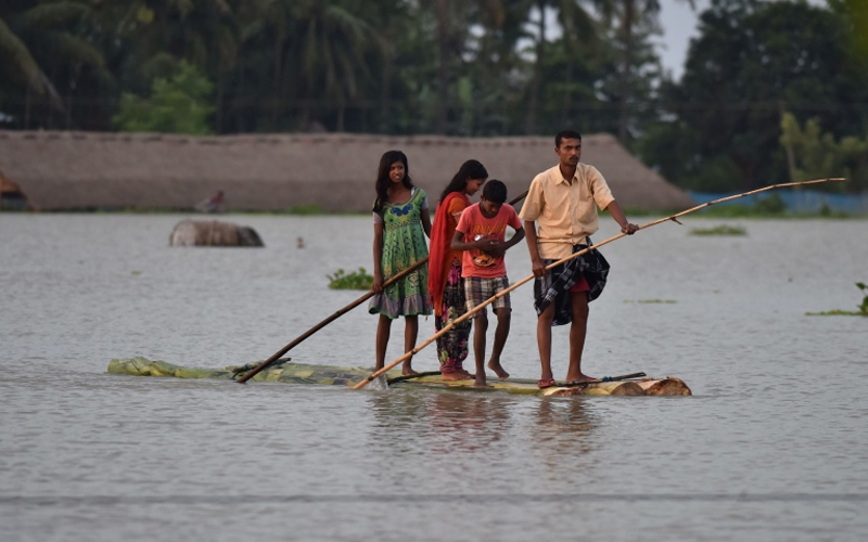
With the arrival of the monsoon in Northeast India, much of Assam gets flooded. It has become an annual affair for all those residing in flood-prone areas. Thousands of people set up tarpaulin tents on higher ground, waiting for the water to recede so they can return to their homes. According to government data, yearly, more than 4 million people are affected by floods.
Because of Assam's distinctive fluvial geography, floods are a way of life for many of the state's rural people. But what would it take to put an end to the annual trail of death and damage left by the raging Brahmaputra and Barak and its tributaries? Is there anything that can be done?
In this piece, we try to put the yearly Assam floods in context – why they happen every year like clockwork; what the government tries to alleviate them; why those measures usually fail to avoid such harm.
 Understanding our
rivers
Understanding our
rivers
The Brahmaputra and Barak River with more than 50 tributaries are the major contributors to severe floods between June and September every year. This causes extensive damage to life and property in both valleys. Believe it or not, the Brahmaputra is so vast during monsoon that it is even visible from space.
Because of the nature of rivers, it is impossible to flood-proof the entire state of Assam, hence floods must be expected.
The Brahmaputra is widely acknowledged as a difficult river to control. It is, without a doubt, the world's most severely sediment-charged river of its size. Add to it, the region's unusual topography: Assam's floodplains are flanked on practically all sides by hills. The river's gradient can reach 16.8 metres per kilometre in Arunachal Pradesh's hills, but it drops to 0.1 metres per kilometre when it approaches Guwahati, Assam. The river unloads massive volumes of sediments in the valley as a result of the steep drop in gradient, which can cause intense floods and erosion.
While rivers Barak and Kushiyara in Cachar districts with their tributaries –Madhura, Sonai, Dhaleswari, Chiri, Jiri, Dalu, Jatinga, and Katakhal – finds its difficult during monsoon as water from Mizoram and other places located above enters these rivers, inundating the plains.
These mega rivers with their dense network of tributaries, the majority of which are larger than many other rivers in India, have their might in full display during the monsoon.
 The
State’s approach to tackling Floods
The
State’s approach to tackling Floods
The overflowing of rivers has a long history of government incompetence and misdirected priorities dating back to the British colonial period, and possibly even earlier.
Every year, the floods hit Assam like clockwork. There will be widespread damage and displacement as a result. All of this is characterised by a feeling of powerlessness on the side of the governmental apparatus. Floods and erosion take us two steps backwards whenever development takes one step forward.When the British pondered developing cash crops in Assam and Bihar, the concern of flood damage prompted the construction of embankments. In flood-prone areas, more embankments were built to protect crops. The policies to deal with the floods in Assam did not change significantly in the post-independence era. After the devastating earthquake in 1950, the state adopted the Assam Embankment & Drainage Act, 1953, to build and maintain embankments. In the last 60 years, state administrations are believed to have spent over Rs 30,000 crore on building embankments.
The ineffectiveness of these embankments is demonstrated by the growing intensity of floods each year. Even when embankments have been successful in safeguarding one target region, they have had disastrous consequences in adjacent areas. To give an example, the embankment at Dibrugarh shields the town from floods, but the change in the flow's course has wreaked havoc on the adjacent villages. Because of the high amount of water, it holds and the increased hydraulic pressure during monsoons, embankment failures are prevalent. Nonetheless, it appears that the only solution to the repeated floods is to keep building embankments.
The sight of the blame game between authorities has become an annual fixture, both between the Centre and the state and between the district administration and contractors. Indeed, the lack of an integrated strategy by the Centre and State is one of the causes for the lack of a proper diagnosis of the problem and its repercussions. The Brahmaputra Board, established under the Brahmaputra Board Act of 1980, lacks cooperation with the state administration, with most operations being decided by New Delhi. The Assam Disaster Management Authority (ASDMA) and the National Disaster Management Authority (NDMA) have a similar lack of coordination. Vulnerable
Wildlife in jeopardy
Vulnerable
Wildlife in jeopardy
The Assam floods submerge more than 80% of Kaziranga National Park, a UNESCO world heritage site. The park located on the floodplains of the Brahmaputra river is home to the world's largest population of endangered one-horned rhinos. It is also one of India's most well-known wildlife tourism sites, with its lagoons and lush woods.
The Assam floods have killed several animals in Kaziranga alone to date, that includes rhinos, several wild boars, wild buffaloes, tigers and deer. During the annual occurrence of floods, several animals relocate to higher ground, coming closer to human populations.
 Floods amidst
Covid-19: Rise of double calamity
Floods amidst
Covid-19: Rise of double calamity
Floods and COVID-19 are a true multi-hazard concern. Many parts throughout the world have been facing this twin peril of severe flooding and pandemic since the beginning of 2020. Following the detection of the first COVID-19 case, floods have occurred in 70 countries, resulting in the evacuation of hundreds of thousands of people.
The State of Assam too experienced a similar flood situation with most of the rivers flowing menacingly above the danger mark. People who have been displaced had to take refuge in relief camps set up across 21 districts, the unhygienic surrounding amidst the pandemic created havoc amongst the people.
During an emergency evacuation, practising social distancing can be very difficult. The two potentially serious emergencies happening at once were a nightmare for the state authorities. This was undoubtedly one of the most challenging flood seasons the state had seen in a while.
Whether it was in response to floods or a pandemic, a resilience approach is required, as well as planning. In addition to defence, the responsible individuals could have been prepared with action plans and command structure, and the general public might have been included in the discussions so that they were informed about the risk and the reasons for the steps they must take. Final Thoughts
Today, Assam has no choice but to take immediate corrective action. To begin, all stakeholders — the federal government, the state, the district administration, and, most crucially, the community — must work together. The focus must shift away from mindless embankment development and toward flood-mitigating strategies that complement existing embankments and reduce flood damage.
In Assam, dams are mostly built for hydropower purposes and lack storage room for flood management, which is one of the fundamental goals of any multipurpose dam. The incorporation of storage capacity in reservoirs could be considered a flood-prevention method. Hazard maps, which show regions that are at risk of flooding or have already been flooded, may be able to help prevent serious damage and deaths.
Raising flood awareness among people in flood-prone areas and guaranteeing the effectiveness of local governments could help lessen the disaster's consequences. The necessity of the hour is for a comprehensive strategic plan to end the cycle of sorrow that has been repeated year after year for decades.
Global warming and deforestation are the two important aspects that one needs to look into as well. The melting of snow capes due to pollution and massive deforestation due to excessive logging, mining, growing human habitat etc. are as well some of the factors that are increasing the risk of floods. The snow capes and forest have been our natural shields against floods and slowly but constantly we have been getting rid of these protections for the worse.
It’s high time we all act.
Disclaimer: The opinions expressed in this article are those of the author's. They do not purport to reflect the opinions or views of The Critical Script or its editor.
Regional Related Posts


Newsletter!!!
Subscribe to our weekly Newsletter and stay tuned.
Related Comments